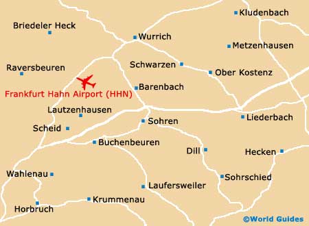
Frankfurt Hahn Airport (HHN)
Orientation and Maps
(Frankfurt Am Main, Germany)
Home to over 640,000 residents, the city of Frankfurt Am Main lies alongside the Main River, which has become its namesake. Known for its dramatic skyline, which is dominated by stunning high-rise buildings, Frankfurt is a particularly important Germany city, with a bustling financial centre and many important buildings.
Apart from the nearby Frankfurt Airport (FRA), the city is also home to an additional airport, the Frankfurt Hahn Airport (HHN), which lies around two hours' away, to the west. Nearer to home, Offenbach am Main is sited on the eastern side of the city, while Mainz, Ingelheim am Rhein and Rüsselsheim are all located on the western side.
Frankfurt Hahn Airport (HHN) Maps: Important City Districts
One of the best ways to get your bearings around the city is to take a cruise along the river, passing many top sights along the way. Regular boats depart from Frankfurt's northern riverbanks and other nearby areas, including the Mainkai.
The southern bank of the Main is known as the Museum Embankment, due to the numerous museums located there. Many historic alleyways, old houses and local bars can be found in this part of Frankfurt. The city's busy central train station is located on the western side of Frankfurt, a short walk from the city centre.
To the east of the train station you will find the An der Hauptwache, a large square featuring a prominent restaurant with an interesting past, since it was once the city's police station. A lively student area of Frankfurt lies to the north-west and is full of bars, cafes and a number of cultural attractions, while for the most impressive architecture, head to the Nordend district.
Germany Map

Frankfurt Map